

Blog: “The USS Macon’s Watery Grave” by Dan Haifley
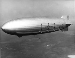
Photo: USS Macon, Credit: U.S. Naval Historical Center/National Archives
Early one evening some 85 years ago, the US Navy rigid airship USS Macon was cruising back to its home port at Moffett Field near Sunnyvale, California after finishing up some survey work over the Pacific. While on a heading to Point Sur on the coast south of Carmel, it flew into a storm.
A wind gust tore its upper fin, which cascaded into a series of structural failures that sent the airship tumbling into the sea. 81 of the 83 crew members thankfully survived, while two tragically perished. The results of an investigation into the cause of the event placed blame on the fact that some damage from a previous, cross-country trip had not yet been repaired. Those who operated the airship that night were not at fault, and actions by the vessel’s commander were cited as preventing more crew members from being killed.
Soon after the USS Macon had left Moffett Field for what would be its final mission, the airship flew over the Twin Lakes area of Santa Cruz County. The Twin Lakes are Schwan Lake and Woods Lagoon, the latter is where the Santa Cruz Harbor now sits.
Film shot with a home movie camera in 1935 by the grandmother of Russ Rolfe, whose family has had a home near the beach at Schwan Lake for generations, records the airship overhead as it heads out over Monterey Bay. The identity of the airship in the brief clip has been confirmed as the USS Macon by Robert Schwemmer, the West Coast Regional Maritime Heritage Coordinator for National Oceanic and Atmospheric Administration’s (NOAA) Office of National Marine Sanctuaries.
The section of ocean floor where the remains of the USS Macon now rest is a maritime heritage site within Monterey Bay National Marine Sanctuary (MBNMS). Research and education about, and importantly the preservation of, this and other cultural and historic sites in the US’ ocean and Great Lakes waters are part of the work done by the staff that manages our nation’s network of marine sanctuaries.
Placed into service in March, 1933, the USS Macon was a state-of-the-art vessel with a data gathering system sophisticated for its day. It was built by Goodyear-Zeppelin Corporation, but unlike today’s blimps it had a rigid frame and an internal hull. Inside its skin was a complex structure of catwalks and girders, which allowed for an efficient use of space as well as enough room to enable the crew to work.
The 785 foot long USS Macon was capable of carrying up to 100 people. When fully loaded, it weighed more than 400,000 pounds and was buoyed by 6.5 million cubic feet of helium. It was 785 feet long. According to the National Park Service, when it crashed into the sea it was carrying four Curtiss F9C Sparrowhawk scout aircraft in its hangar bay.
Thus, after being in service less than two years, the USS Macon came to rest on the ocean floor on February 12, 1935. It lies at a depth of about 1,500 feet within MBNMS, which has the authority and access to expertise necessary to preserve and manage the site as a historic resource. It’s been the subject of intense research over the years. A video about the airship and its history can be viewed here.
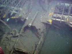
Photo: Cockpit of a Sparrowhawk from USS Macon at rest on the ocean floor. Credit: NOAA and MBARI
While I worked on the development of the sanctuary in 1992 I reviewed a draft of its rules and management plan when a proposal to protect submerged “historical resources” caught my attention. I did not know then that there was a keen interest in the USS Macon site off Point Sur.
According to an account provided by MBNMS staff, the airship’s precise location remained a mystery from 1935 until the mid-1980s when a commercial fisherman caught a piece of its girder in his net, which was displayed in a Moss Landing restaurant where Marie Wiley Ross noticed it. Ross’ father, Lieutenant Commander Herbert Wiley, had skippered the USS Macon when it went down and had survived, and whose actions have been cited as one reason so many crew members survived.
Scientists in the Monterey Bay region later became aware of the girder’s connection to the submerged airship. According to MBNMS staff, Dick Sands at the National Museum of Naval Aviation Foundation had learned of a 1988 expedition which tried, but did not find, the Macon’s remains where the airship had gone down.
Silicon Valley pioneer David Packard, who founded Monterey Bay Aquarium Research Institute (MBARI) as well as the Monterey Bay Aquarium and had served as a deputy U.S. Secretary of Defense, had also taken an interest in the project. In 1990, MBARI went out in search of the Macon’s watery grave, using the location where the restaurant-displayed girder had been found. It was a success.
The institute conducted another survey in 1991, then returned 14 years later returned as part of a larger exploration of cultural and archeological sites. In 2005, a NOAA vessel was used to conduct a side-scan sonar survey at the site. Then, in September 2006, the institute returned again for more research with staff from the Monterey Bay National Marine Sanctuary and Stanford University.
The 2006 survey of the USS Macon’s location, which is officially a secret, produced more than 10,000 photographs, video and data. Thanks to efforts by MBNMS staff after their 2005 and 2006 expeditions with their partners, in 2010 the site was officially listed in the National Register of Historic Places. It’s also listed as a U.S. Navy gravesite.
A video about research and exploration at the site by MBNMS, MBARI and their partners can be viewed here. Work on the USS Macon site is just one example of the work that is being done to preserve, learn about and inform the public about significant pieces of our heritage that rest in ocean and Great Lakes waters.
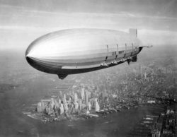
Photo: USS Macon over Manhattan. Credit: Wikimedia Commons
Physical reminders of significant events in our collective past aren’t just found on land. Some of them are underwater, which is why the staff of our nation’s network of national marine sanctuaries works to preserve, research, and education the general public about our cultural and maritime heritage. These sites tell the stories of our collective past.
In fact, the first national marine sanctuary was established in 1975 to protect the wreckage of the USS Monitor, a U.S. civil war ironclad known for its epic 1862 battle with its confederate counterpart CSS Virginia. The Channel Islands National Marine Sanctuary, 25 miles off Santa Barbara, California, has more than 150 shipwrecks and benefits from knowledge of the maritime activity of indigenous peoples. And the proposed Chumash Heritage National Marine Sanctuary, which if approved would be located off San Luis Obispo and northern Santa Barbara counties, would preserve sacred Native American cultural sites.
This work to preserve our collective heritage is one of many reasons to support Monterey Bay National Marine Sanctuary, and other national marine sanctuaries as well as marine national monuments. To learn more about what’s happening within our nation’s underwater treasures, you can follow NOAA’s National Marine Sanctuaries, Monterey Bay National Marine Sanctuary, Monterey Bay National Marine Sanctuary Foundation and the National Marine Sanctuary Foundation on Facebook, and Instagram. Also, you can donate to support advocacy, as well as education programs and whale rescue in Monterey Bay National Marine Sanctuary.
By Dan Haifley, Secretary of Monterey Bay National Marine Sanctuary Foundation’s Board of Directors; former Executive Director of O’Neill Sea Odyssey and Save Our Shores.
Thank you to Paul Michel and Erica Burton of MBNMS for their guidance and Russell Rolfe Jr. for supplying video footage. The material in this blog previously appeared in the author’s Our Ocean Backyard columns in the Santa Cruz Sentinel.